Last Updated on September 6, 2018
Families, friends, walking groups, day-trippers, long-distance ramblers and adventure-scramblers, get ready. Whatever type of walker you are, it’s sure that the fair and great British Isles will have a trail for you. Forget about weather woes and do as the Brits do – pack a raincoat (whatever the season), lace up those hiking boots and head for the hills with our pick of the best of British hiking trails.
1. Hadrian’s Wall Path
If you’re a history buff, this one’s definitely for you. The entire walk spans 84 miles (135 kilometres) from coast to coast in the very north of England from Wallsend near Newcastle upon Tyne in the east to Bowness-on-Solway on the west coast. The path takes hikers along the World Heritage Site of Hadrian’s Wall, which was the north-west frontier of the Roman empire for nearly 300 years. You’ll pass through Roman settlements and forts, over moorlands and fields, along ridges and crags, by villages and towns with cosy pubs, and enjoy vistas that are at one turn dramatic and at another pastoral. Those looking for a challenge can do the whole route in about a week, and finding your way along the trail is easy thanks to the well-marked arrows and acorn symbols highlighting the National Trail. Casual walkers fear not; there are plenty of shorter routes that cover stretches of the trail and are no less dramatic or picturesque. Find out more about Hadrian’s Wall Path and planning your trip on the National Trails website.
Best airport to fly to: Newcastle Airport. From there you can take an airport transfer to Wallsend if you want to start hiking straightaway, or to the city centre if you’re staying in a hotel and exploring the buzzing north-eastern city before you start hiking.
2. Pennine Way
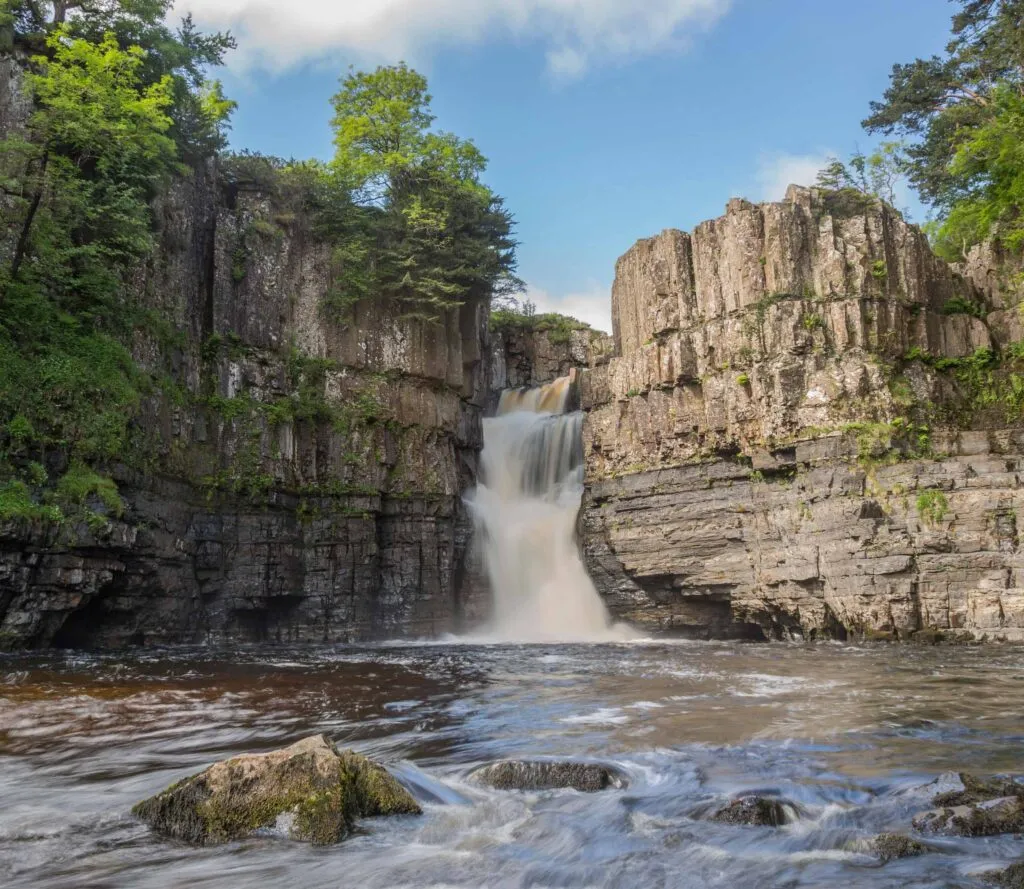
Opened on the 24 April 1965, the Pennine Way became the first National Trail; designated long distance walking routes through some of the best landscapes in England and Wales. There are 15 National Trails, with the Pennine Way being the most famous, and arguably one of the most challenging. This 268 mile (429 kilometre) track begins in Edale in Derbyshire, England and ends in Kirk Yetholm in the Scottish Borders, and takes walkers across some of the most beautiful landscapes in the county, including the Peak District, the Yorkshire Dales, the North Pennines, Hadrian’s Wall and the Cheviots. Highlights on the historic route include lots of highs of England: the highest pub, the Tan Hill Inn in the Yorkshire Dales; one of the highest waterfalls, High Force; and highest market town, Alston in Cumbria. The route can be remote and wild in sections and very hilly, with changing underfoot conditions – some sections have smooth paths, whereas others can get notoriously boggy and wet. The best time to walk the route is between May and September, as earlier or later and you could be faced with snow and cold, wet conditions. If you’re taking on the challenge of the full route, expect to take around three weeks, less if you’re prepared and have the legs and stamina for the hills. Many people do sections of the walk, ranging from day walks to week walks, taking in sections of the beautiful route. Make sure you bring your waterproofs for this one!
Best airport to fly to: If you’re taking on the whole route, it’s recommended to walk in the south to north direction. The start of the Pennine Way in Edale is less than 50 kilometres from Manchester Airport. When you reach the end in Kirk Yetholm, both Edinburgh Airport and Newcastle Airport are the nearest options.
3. South Downs
Way This 100 mile (160 kilometres) route crosses between the historic centre of Winchester (the first capital of England) and the chalky cliffs of Eastbourne, talking ramblers through open heath and ancient woodlands and showing off the beauty of the south-east of England. To walk the entire South Downs Way generally takes eight or nine days depending on how many miles you clock up each day. It’s also popular for weekend walkers wanting to get out of the hustle and bustle of London as there are train stations easily accessible to different sections of the path.
Best airport to fly to: London Gatwick, but if you’re flying into any of London’s airports, you can take an airport transfer to Winchester, where the western end of the route starts – we’d recommend walking west to east, as you’ll finish along the spectacular cliffs of Eastbourne.
4. Cleveland Way
This 109 mile (175 kilometre) trail winds its way from Helmsley, on the southern edge of the North York Moors National Park in northern England, to Filey on the east coast, and has been a designated National Trail since 1969. It’s easy to see why this route is so popular; winding over heather moorlands, through forests and along escarpments, past castles and fortifications, through traditional villages, and ending on the dramatic coastline of the north-east of England with pretty fishing villages such as Runswick Bay and more well-known seaside towns such as Whitby (whose Abbey was the inspiration behind Bram Stoker’s Dracula), walkers along the Cleveland Way are treated with panoramic vistas and beautiful views at every turn. The whole trail can be done in around nine days, depending on how long you want to stop off and see the sights along the way, but shorter walks and one- to -two-day walks are also possible. Plan your trip and find out about nearby accommodation on the National Trails website.
Best airport to fly to: Leeds Bradford Airport is the nearest airport, but it also possible to fly to Manchester or Newcastle Airports.
5. West Highland Way
This long-distance trail stretches 96 miles (154 kilometres) across one of the most breathtaking parts of Scotland, from Milngavie to Fort William, and is the perfect introduction to the beauty and wild-nature of the Scottish Highlands. From loch-shores to dense forests, gentle countryside to wild moors and dramatic mountains, this route takes walkers through some of Britain’s most magical landscapes, ending up near the foot of Ben Nevis, the highest mountain on the British Isles. Most experienced hikers will walk from south to north to allow the preparation for the more challenging later stages of the trail, and on average it can take six to seven days to walk the entire Way. Many like to split the walk up into sections, and the West Highland Way website has information on itineraries and planning your hike. Spring and Autumn are the favourite months for hiking the Way. From November to March, the walk should only be undertaken by experienced and equipped walkers as winter conditions of snow and ice are common, while in summer be prepared for the Highland midge – insect repellant is essential!
Best airport to fly to: Glasgow Airport is highly convenient for walking the West Highland Way. If you walk south to north you’ll start in the town of Milngavie, which is less than 10 miles (16 kilometres) from Glasgow. Either hop in an airport transfer to Glasgow city centre for the night, or head straight to Milngavie to base yourself ready for the walk.
6. Helvellyn
The Lake District is one of the most picturesque and stunning areas of the United Kingdom (so much so we named it one of the Top 11 Destinations For 2018). Glistening lakes, towering fells, pretty villages and pastoral vistas greet every visitor, and you could easily while away days reading books and enjoying the views here. But you’d be missing out if you didn’t join the locals and stretch your legs on some of the area’s most famous routes and more than 200 fells. Most visitors like to tick off Scafell Pike, which at 978 metres is England’s highest mountain. But the 950-metre Helvellyn gets our vote. This peak is famous for its twin ridges – Striding Edge and Swirral Edge – caused by glacial action during the last ice age, and epic views over the surrounding countryside. The most popular routes start in Glenridding or Patterdale and range between 8-10 miles. Like many of the fell walks and peak climbs in the Lake District though, only attempt this on a clear day. The ridges are narrow and the weather can change quickly up high, so make sure you’re prepared and know the safest route for your walking abilities.
Best airport to fly to: The nearest airport to the Lake District National Park is Manchester Airport, which is around 150 kilometres from Lake District towns such as Kendal and Windermere, so it’s a good idea to pre-book your airport transfer before you fly
7. Snowdon
We couldn’t finish our list without walks that scale at least one of the famous Three Peaks of Great Britain. Ben Nevis, Scafell Pike and Snowdon combine to make the highest mountains of Scotland, England and Wales, which every year thousands of hikers take on in 48 hours in the National Three Peaks Challenge.
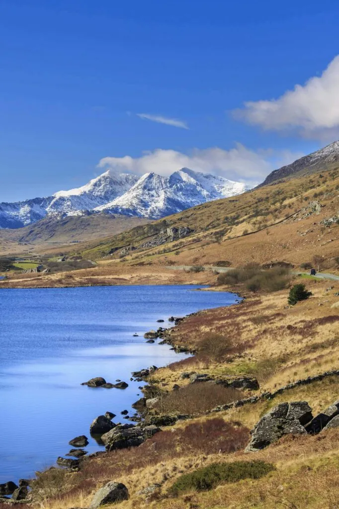
Out of the three, Snowden is the second highest at 1,085 metres, and the many hiking routes up and around Snowdon are some of the most popular in the UK. Wales is a land of legends, dragons, ice age landscapes and breathtaking scenery, and the best way to take it all in is from the top. To reach the summit of the famed mountain there are six different hiking tracks to choose from; Llanberis Path, Miners Path, Pyg Track, Watkin Path, Rhyd Ddu Path, and Snowdon Ranger. Llanberis Path is the most gradual and is the best option if it’s your first time summiting Snowdon. At 9 miles (around 15 kilometres) it’s about a six hour return hike and offers spectacular views over the region. Snowdon is a popular mountain to hike, especially during the summer months. If you can, aim to walk during the week and outside of the main summer months – September and October can be really good months to visit. If you want to hang your hiking boots up for the day, you can get to the top of the mountain on the Snowdon Mountain Railway.
Best airport to fly to: Manchester Airport and Liverpool John Lennon Airport are the best airports to fly to as both are just over two hours from Snowdon.
Whichever mountain, Way, fell or track you decide to take on, give your feet a rest at the beginning and end of your trip by taking an airport transfer to and from the airport. Plus, it’ll give you more time to enjoy the scenery rather than waiting in taxi queues!